
Published: 29 October 2026 | Last updated: 29 October 2026
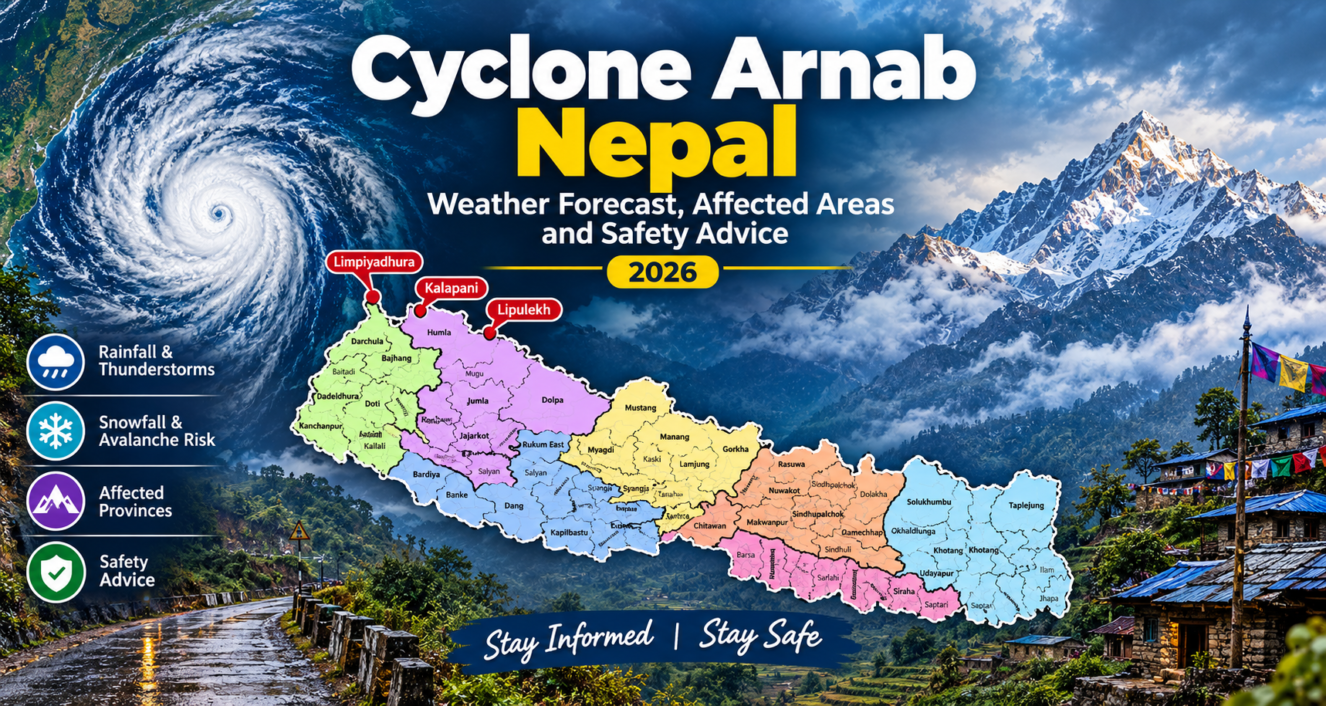
Nepal’s authorities have issued weather alerts for the forecast impact of Cyclone Arnab. The storm is expected to bring rain, thunder and heavy snow to higher elevation areas in Nepal from the late evening of October 29th through October 30th and 31st, 2026. Reports from Nepal’s Department of Hydrology and Meteorology (DHM) suggest that multiple provinces in Nepal could experience adverse weather conditions, while the Himalayan region is at risk for snowstorms and avalanches.
The storm is not expected to directly landfall in Nepal. Rather, the moisture from the cyclone is expected to interact with the weather patterns in the Himalayas and cause rain and snow in Nepal. Residents, farmers, trekkers and travelers should monitor official forecasts and check local conditions before planning any activity.
What is Cyclone Arnab in Nepal?
The Cyclone Arnab Nepal weather forecast, as reported from DHM guidance, places the start of the storm’s influence on the night of Thursday, 29 October. The period of greatest concern in the Cyclone Arnab Nepal weather forecast for October 2026 is 30–31 October.
The National Disaster Risk Reduction and Management Authority (NDRRMA) has reportedly urged people and relevant authorities to stay on high alert from 29 to 31 October. Its website carries a “Request for High Alert” notice.
Treat these dates as a forecast, not a record of events. Timing and intensity can shift as the system weakens or changes direction, and the newest DHM bulletin always takes precedence over earlier reports, including this article. We will update this page as bulletins change.
When will Cyclone Arnab affect Nepal?
According to the reported Cyclone Arnab Nepal weather forecast, the cyclone’s influence on Nepal may begin late on the evening of Thursday, October 29th, with the main period of concern being Friday and Saturday, October 30th and 31st.
Reports attributed to DHM indicate that the storm’s impact began on Thursday, 29 October. The most critical time frame is 30-31 October. Reports indicate that NDRRMA has called upon the public and concerned agencies to remain on high alert from 29 to 31 October. A “Request for High Alert” is posted on NDRRMA’s website.
Please view these dates as forecasts rather than records of events. As the storm weakens or changes path, both timing and intensity may vary; therefore, each new bulletin from DHM supersedes previous ones (including this one). We will provide updates to this page as new bulletins are issued.
Which areas of Nepal could be affected?
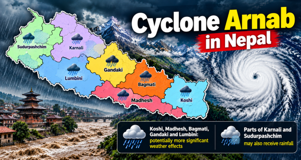
Most of the people who are searching for cyclone Arnab affected areas in Nepal will find that it is not the same when it comes to the forecasted cyclone zone. So, which provinces will be affected by Cyclone Arnab? The pattern below reflects what several outlets have attributed to the DHM. Reports citing the DHM identify Koshi, Madhesh, Bagmati, Gandaki and Lumbini as provinces that could experience more significant weather effects. Parts of Karnali and Sudurpashchim may also receive rainfall.
These are forecast risks, not confirmation that every province listed will experience severe weather.
Koshi, Madhesh and Bagmati
Moderate rainfall, thunderstorms and strong winds are possible in parts of these provinces, with heavier rainfall in some locations. In the Terai, Chure and lower hills, heavy rain could create slippery roads, localized flooding and difficult travel conditions.
Residents should be especially cautious near rivers, drainage channels and slopes vulnerable to landslides. Farmers should also consider the forecast when planning outdoor work during the rice-harvesting season.
Gandaki and Lumbini
Gandaki and Lumbini are also listed in reports of potentially affected areas. Rainfall may disrupt road travel, while conditions could deteriorate rapidly at higher elevations.
Travelers heading toward mountain destinations should check local advisories prior to departure. A route that remains passable in a lower valley may become hazardous further uphill.
Karnali and Sudurpashchim
Parts of Karnali and Sudurpashchim could receive rain and thunderstorms, with isolated heavy rainfall possible. The expected severity may vary by location, so people should not assume that areas outside the provinces highlighted most prominently are risk-free.
High Hills and Himalayan Areas
High-altitude areas face a different set of concerns. Forecasts warn of heavy snowfall, snowstorms and possible avalanches in the high hills and Himalayan regions.
Snow can reduce visibility, cover trails and make mountain passes difficult or impossible to cross safely. Strong winds can make conditions even more dangerous, especially for trekkers and climbers who are far from sheltered accommodation.
Rainfall, Snowfall and Avalanche Risks
Cyclone-related weather may create several hazards across Nepal depending on elevation and local conditions.
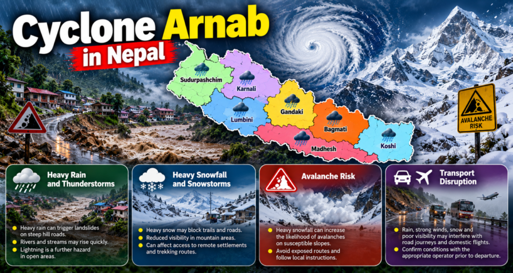
Heavy rain and thunderstorms: At lower elevations the reported Nepal heavy rainfall warning centres on rain and thunderstorms. Heavy rain, where it falls, can trigger landslides on steep hill roads and make rivers and streams rise quickly. Lightning is a further hazard in open areas.
Heavy snowfall and snowstorms: In mountain regions, heavy snow may block trails and roads, reduce visibility and leave trekkers exposed to severe conditions. Snowfall can also affect access to remote settlements and trekking routes.
Avalanche risk: Heavy snowfall can increase the likelihood of avalanches on susceptible slopes. While the existence of a warning does not guarantee an avalanche has occurred, it is a reason to avoid exposed routes and follow local instructions.
Transport disruption: Rain, strong winds, snow and poor visibility may interfere with road journeys and domestic flights. Travelers should confirm conditions with the appropriate operator prior to departure.
At the time of writing, the reports cited here describe forecast hazards. They should not be interpreted as confirmation that every predicted event has occurred or that every province has suffered damage.
Nepal’s steep terrain means that prolonged or intense rainfall can rapidly increase runoff. Small streams can easily rise and saturated hillsides can become unstable. Roads cut into steep slopes are particularly vulnerable to landslides and debris flows.
Flooding is an important hazard to consider when assessing severe weather in Nepal. Our report on the Budhi Gandaki flash flood in Gorkha in Nepali provides a related example of the risks that flooding can pose to communities.
The most important precautions are to avoid crossing flooded roads or streams and stay away from riverbanks during rising water levels, and follow road closures and local evacuation instructions. A trail that may be visible from a distance can turn out to be hazardous.
Possible Impact of Cyclone Arnab on Trekking, Roads and Flights
The Cyclone Arnab impact in Nepal could be felt most directly by travellers. Below we distinguish between recognised restrictions and risks foreseen.
Is it safe to trek in Nepal during Cyclone Arnab?
This depends on location, elevation and your operator’s advice. From 28 October, inner Nepal reported limited area trekking permit suspension starting from 29 October 2020 until 31 October 2020. Department of Immigration has not issued any notice, so the exact scope of the suspension is unconfirmed.
This does not mean that you cannot trek in Nepal. If you have a permit for a restricted area, please contact your trekking agency and the Department of Immigration. If you are trekking in a non-restricted area, please check with your guide regarding the condition of the trail prior to leaving.
Could roads be affected?
There may be landslide risks and difficult driving conditions on some of the mountain roads. However, at this time we do not know if any particular road is closed. Please check with local traffic police, road authorities and drivers prior to departure.
Will flights be disrupted?
Domestic flights can be affected by clouds, rain and wind; especially when flying over mountains. At this time, we cannot confirm if any specific flight has been cancelled due to weather conditions. Nothing suggests that all flights have been suspended. Please check directly with your airline.
Safety Advice for Residents and Travellers
The following precautions can help minimize risks during the forecast period:
- Follow official updates: Monitor the DHM and NDRRMA rather than relying on unverified social media posts.
- Avoid unnecessary high-altitude travel: Postpone exposed mountain journeys if authorities, local officials or your guide advise against traveling.
- Check before departure: Confirm road conditions, flight status and trekking arrangements with the relevant operator.
- Stay away from rivers and unstable slopes: Avoid riverbanks, flood-prone areas and locations vulnerable to landslides during heavy rain.
- Prepare for delays: Keep your phone charged and carry appropriate clothing, drinking water, essential medicines and basic supplies if travel is necessary.
- Protect agricultural work: Farmers should monitor forecasts and plan harvesting and other outdoor activities around expected rainfall.
- Take care when photographing outdoors: Avoid exposed ridges, unstable slopes, river edges and open areas during lightning or severe weather. Do not risk your safety for a photograph.
For weather information, recent reports have listed DHM’s telephone service at 1155. Verify current emergency contact details through official channels.
FAQ
What is Cyclone Arnab, and how could it affect Nepal?
Cyclone Arnab is a Bay of Bengal cyclone which was reported to have made landfall in Andhra Pradesh on 28 October. Indirect impacts on Nepal include rain and thunderstorms in low-lying areas; and high-altitude snowfall.
Will Cyclone Arnab affect Nepal?
The DHM forecast indicates that Cyclone Arnab will affect Nepal indirectly through weather effects. To stay updated on the latest information, refer to the most recent bulletin.
When is Cyclone Arnab expected to affect Nepal?
The DHM forecasts indicate that the majority of Cyclone Arnab Nepal effects will occur on Thursday night, 29th October, with the main event occurring on 30/31 October.
Which provinces could receive heavy rainfall?
Koshi, Madhesh, Bagmati, Gandaki and Lumbini were reported as experiencing moderate rain, with heavy rain being possible in some areas. Isolated heavy rain may occur in Karnali and Sudurpashchim.
Is it safe to trek in Nepal during Cyclone Arnab?
No. Permits for restricted areas were reported as suspended from 29rd – 31st October and there is a high risk of avalanches and heavy snow at high altitudes. Consult with your agency, guide or the Department of Immigration.
Where to check official Nepal weather warnings?
Official weather warnings for Nepal can be found on the websites of the DHM, NDRRMA and the Department of Immigration (Permit notices). Storm tracking is done by the India Meteorological Department.
Conclusion
The Cyclone Arnab Nepal forecast points to a potentially hazardous period involving rain, thunderstorms and mountain snowfall around October 29th-31st, 2026. The most significant concerns are possible heavy rainfall in parts of the lowlands and hills, landslides and travel disruption, and heavy snowstorms and avalanche risks at high elevations.
The forecasts describe possible impacts rather than confirmed damage across Nepal. Residents, farmers, photographers and travelers should follow official updates, verify local conditions and avoid unnecessary journeys into exposed areas while warnings remain in effect.
Before traveling, consult the latest official forecast rather than relying solely on this article. Weather conditions can change, and new advisories may supersede the information reported here.
Reports referenced:
- The Himalayan Times
- Nepal News
- Onlinekhbr
- Inner Circle Nepal: trekking permits, 28 October
- DHM
[…] read latest news on Cyclone Arnab Nepal: Weather Forecast, Affected Areas and Safety advices 2026 […]